Sunday, May 26, 2013

A Long Overdue Post

It has been an embarrassingly long time since I’ve blogged. I’d offer excuses but they would probably come across as pretty lame, mainly because they are in fact pretty lame. A lot has happened since the last posting, so let’s get you caught up!

First things first, Jess is now back in the US and working at the University of Minnesota Hospital. We decided that it was better for her to return a bit earlier than me to secure a job before the new graduates saturated the market. It’s already paying dividends, as she’s gotten a great gig. That leaves me here in Dunedin, plugging away on my MA. I’m on track to finish in August but there is a lot of work left to do. Now on to some adventures. Since I last blogged we visited the world’s largest sea cave, the world’s steepest street, and the imagination of J.R.R. Tolkien. It has been a pretty crazy couple of months.

Our main chunk of traveling was at the beginning of February. This is right at the end of the southern hemisphere summer, just before the first semester of the new school year got going. For this trip we spent 10 days traveling the North Island in a rented van.
Our home for the week

Our first stop after flying into Auckland was Whangarei, a coastal town in the Northland, which is the long thin peninsula at the top of the North Island. We stayed in campsites throughout the trip, but this was by far the best location. Our spot was right on the water.
 
Our Campsite


Breakfast by the water


The first day in Whangarei involved a visit to Whangarei Falls. It’s a beautiful waterfall just outside the city and on the edge of a forest. From the falls there are a number of walking tracks, one of which leads to a Kauri forest canopy walkway. Kauri trees are amongst the largest trees in New Zealand and the oldest trees in the world. The canopy walkway took us through the tree tops and by some massive Kauri trees. After a lunch back by the waterfall, we drove to Ocean Beach for some required beach relaxing time.


Whangarei Falls

Canopy walkway

One big Kauri Tree


The next day in Whangarei we took a visit to the Poor Knights Islands, one of New Zealand’s most popular snorkeling spots. The chain is made up of two larger islands and a number of smaller islets. The island group is also surrounded by the Poor Knights Marine Reserve due to the unique flora and birdlife. After a 30 or so minute ride to the island our boat set up in a beautiful dive spot, in a small protected part of one of the islands. No sooner had we put down the anchor then one of the crew members spotted a manna ray, at which the entire crew (minus the captain) jumped in the water to get a look at it. Once the crew returned it was our turn to snorkel. The water was great, it was crystal clear and not unbearably cold once you recovered from the initial shock. It was also immediately obvious why this was such a popular snorkel spot. The water was teaming with fish, and the rocky, rugged coast meant that just beneath the surface were incredibly interesting rock formations to explore. Our boat also had a number of kayaks, so after snorkeling for a while Jess and I took a kayak out along the island and into Rikoriko, the world’s largest sea cave. It was suitably massive, and amazingly quiet. Our boat also took us inside on our way back to mainland.


At Poor Knights Islands

Rikoriko Cave

Through a channel amongst the islands

Poor Knights Island


We left Whangarei the next day for the next stop on our North Island tour, Hot Water Beach on the Coromandel Peninsula. We stayed at a camp site about five minutes walk from Hot Water Beach, a stretch of beach which happens to be right on top of some hot springs. At low tide you take a shovel out to the beach and search till you find a hot spot. Then you dig a hole and allow some spring water to escape, and voila! You have your self a ready made jacuzzi. Jess and I went to Hot Water Beach fully expecting to get Moeraki Bouldered, i.e. underwhelmed, but were pleasantly surprised to find that the beach was actually really awesome. When we visited the beach it was at the tale end of when you can actually build your hot pool in the sand, and so we had to constantly fortify our hole with a seawall. Though, in the end we were glad that so much seawater got in because the spring water was scalding hot! The other big highlight of our time in Coromandel was our walk to Cathedral Cove. Coromandel Peninsula is one of the most scenic places on the North Island, and Cathedral Cove might be its best spot. It is only accessible by foot or boat and is a beach centered around a massive cave/archway and surrounding rock formations. It is an incredible place.


On the way to Cathedral Cove

A quick break to enjoy the view

The archway


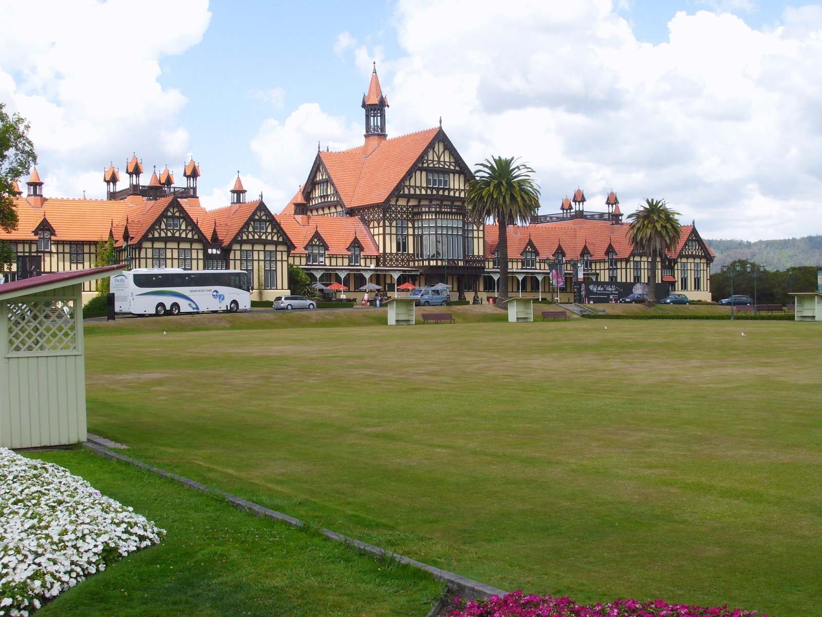
After a few days on the Coromandel Peninsula we drove down to Rotorua, which is known in New Zealand as Roto-Vegas. The entire city is centered around tourism, and reminded me of the Wisconsin Dells. All of this also fails to mention Rotorua’s introductory feature, the smell. The city sits right on the banks of Lake Rotorua, and was originally settled by the Maori because of its geothermal activity. The area is filled with hot pools, geysers, and hot mud pools. This means that the entire city also smells like sulphur. You got used to the rotten eggs smell after a while, but every now and again you’d get a real good whiff that could make your stomach turn.

Rotorua Museum

Our first day in Rotorua was spent visiting the Rotorua Museum, which is located in an old bathhouse. At the beginning of the 20th century there was a big push to make Rotorua, with its abundant hot pools, a sort of health definition. It didn’t quite work out that way, but it prepared the city for its future as a tourist center. On our second day we took a nice coffee cruise around the lake on the Lakeland Queen. It was a fun cruise, though based on the commentary we both decided that our guide did not fully understand the concept of a ‘joke’.


The Lakeland Queen

That night we visited Te Puia, which is the home of the New Zealand Maori Arts and Crafts Institute and is located amongst a massive geothermal area, for an indigenous experience. We started with a tour of the park, which included hot mud pools and Pohutu Geyser, the largest geyser in the southern hemisphere. The park also had a kiwi hut, and so we saw kiwi birds for the first time. I’m not going to lie, they are really odd looking creatures. We also got to see the Maori Carving School, which is where young Maori men are invited to learn their culture’s most important art form. After touring the park, we saw a traditional Maori show and attended a hangi, a traditional Maori feast. The main staples are chicken, pork and kumara, a New Zealand variety of sweet potato, which are cooked over hot coals for a number of hours underground. The show was really cool, both of us went up on stage. Jess learned a traditional dance, and I learned the haka. The food was also delicious.

Pohutu Geyser
Lots of geothermal activity here

Our hangi dinner

Kiwi thataway


The sheep show
On our last day in Rotorua we visited the Agrodome for the world famous sheep show. It was cheesy, over the top, and absolutely fantastic. The show introduced us to all the sheep breeds raised in New Zealand, showed off the skills of the sheep dogs, and included a sheep shearing. It was really interesting, and very funny. It was the most touristy thing we did in our time in New Zealand, but also one of the most fun things we did. After the show we took a tour of the farm on which the Agrodome is located, which was also really interesting.
Meeting the stars of the show


The final stop of our North Island trip, before heading back up to Auckland for the flight home, was a visit to Hobbiton. The movie set is located outside of Matamata which is in the middle of the North Island country side. We drove to the middle of nowhere just to get to the visitors center, and then had to take a bus further into the middle of nowhere to get to the actual set. It is amazing how much detail and depth there is to the place. For instance, our tour guide told us that before filming each Hobbit Hole was assigned a crewmember whose job was to walk from the front door to the laundry line twice a day. They did this just to wear down paths so that the homes looked lived in. That kind of attention to detail is all over the set. The best part was that at the end of our tour we visited the Green Dragon, a working pub. The two of us got the chance to sit in Hobbiton and enjoy a drink in the pub from the Lord of the Rings. This is certainly not something either of us expected to do.


Hobbiton!

A view of the Shire
Bag End
The Hobbit Holes are bigger than you'd think
Even Hobbits need road signs
At the Green Dragon

Enjoying a pint in the Shire


After returning to Dunedin from our North Island sojourn, we tried to visit some of the city’s sites before Jess’ return to the US. Our favorite was Baldwin Street, the steepest street in the world as recognized by the Guinness Book of World Records. This was another seemingly silly tourist thing which turned out to be really cool. The walk to the top was a real gutbuster though.
The steepest street in the world
Wellington's waterfront

Jess departed for home in mid-March, and flew out of Wellington. This gave us a chance to have a short trip there together before she left. We spent four days relaxing and enjoying the city. Wellington has a beautiful waterfront, and a reputation for lots of cool restaurants and cafes. We had a great time just exploring the city. Every one of the four days we were in Wellington we also visited Te Papa, which is the New Zealand National Museum. It is a really incredible place; it is massive and contains everything from a mild earthquake simulator to the worlds largest known Colossal Squid specimen (it measured 33 ft when it was caught). It also contained a number of nice cafes, free internet, great hours, and amazing brownies. So, every day while we were in Wellington we walked there, got a coffee and a brownie, and visited a new exhibit. We also took the chance to visit Weta Workshop, the special effects studio that is most famous for their work on the Lord of the Rings. While there we took a backstage style tour to the workshop itself to see how the place operates, which was really cool. The combination of craftsmanship and technology is really amazing.
An early birthday dinner

That about sums up our most recent bout of adventures. With Jess back in the US, and me trying to finish a thesis we won’t have many more to blog about. The last big trip on the docket is my visit to Australia. I’ll be spending some time in Sydney and then Brisbane for a conference, so perhaps I’ll blog about that visit. For the time being, I hope you enjoyed reading!

Thursday, January 24, 2013

Summer Road Trip


Now that Jess and I have settled back into life in Dunedin, it’s time to blog about our first big summer road trip. We spent 9 days, January 4th through the 10th, driving up to the northern part of the South Island and back again. It was quite the trip, so I’m going to break it down by day. Also: Happy Birthday Dad!

Day 1: Departure
We left Dunedin for Nelson on the morning of January 4th. It is a full day's drive and takes you from almost the bottom of the South Island to the top. The first stretch of our drive took us to Christchurch, about 4 1/2 hours north of Dunedin. It wasn’t the most exciting drive in the scenery department, primarily just flat and more flat. The drive certainly made up for that once we’d passed Christchurch, though, as we turned west to cross the Southern Alps through Lewis Pass. This stretch was almost too exciting! We were driving through a forest and along the side of a mountain simultaneously. There were lots of curves (at one point we were in the midst of what seemed like a series of 6 or 7 90 degree turns) and narrow roads, but the scenery was breathtaking and made it worth the effort. We also stopped for lunch in the mountains, finding a rest stop right next to a river just before Lewis Pass. 


Lunching in the mountains
There were quite a few remnants of a big storm that had passed through the South Island a couple of days before. A number of spots along the road had only one lane open, because the other lane was washed away by the flooding river! In fact it turned out that we were lucky to get through the pass; a few of our friends had left a couple of days before we did and found their way through the Southern Alps closed. 

Finally, after a full day of driving we arrived at our hostel in Nelson. It was very nice, with new rooms, a beautiful patio dining area, and a full bar attached. After rehydrating and having some dinner we decided to explore the city a bit. Nelson is a beautiful little town, famous in New Zealand for its great weather, but as we discovered it is also a bit expensive to eat out (of course Dunedin is a college town, so the prices may be lower for a reason). We also walked down to the harbor area to try to catch the sunset by the sea. Unfortunately the tide was out so far that the sea wasn’t even visible! So, after a bit more exploring we headed back to the hostel for the night. 

Day 2: Market and Beach
We started our second day in Nelson bright and early so that we could beat the rush to the Nelson Market. The market is held every Saturday morning in Nelson year round, but it isn’t really a farmers market. Instead its focused on crafts, everything from jewelry to woodcarving. The market itself was huge, and we spent a couple of hours walking up and down the rows of stalls. In the end Jess picked out a beautiful wood carved bowl, and we found a really cool rimu wood spatula. After the market we dropped our stuff off at the hostel before heading back into the center of Nelson to find the forge of the One Ring. The making of the One Ring was undertaken by a local goldsmith, who still runs a store in Nelson. Besides a sign out front and a small display inside the shop, however, you wouldn’t realize it was anything other than a small local jeweler. Still, it was cool to see and they do have replicas of the One Ring for sale of course. 
Forge of the One Ring

Frozen yogurt!
After seeing the forge of the ring we got some frozen yogurt, and walked over to the Suter Art Gallery, which houses a lot of Kiwi-centric art. We poked around there for a bit, they had an especially interesting photography exhibition, and then walked back to the hostel via the Queen’s Gardens. The gardens are a beautiful walled off area in the middle of town complete with ponds and streams, and lots and lots of ducks. Once we got back to the hostel we had some lunch and then decided to walk to the beach. The walk was a bit longer than we expected, but it turns out that a part of it was a penguin crossing! We spent a good couple of hours relaxing beach side before walking back, stopping for some fish and chips on the way. 


Queen's Gardens
Penguin crossing


Day 3: The Center of New Zealand

Marker for the 'center'

We started our second full day in Nelson with a walk on the center of New Zealand track. The track starts on the edge of town and takes you up to the top of a hill overlooking Nelson, a hill which is also known as the center of New Zealand. The views of the city and ocean were pretty amazing. The supposed center of New Zealand on the other hand was a bit of a let down. Since the region of which Nelson is a part is the most central region in the country the central surveyors point in the Nelson area has become known colloquially as the 'center' of New Zealand. So in a geological or geographic sense it is not the center of New Zealand, but that didn’t stop the city of Nelson from erecting a plaque and monument!  Once we’d finished the track we headed back to the hostel for lunch before going for a walk around the city. Eventually we wound up hanging out in the Queen’s Gardens for a few hours; hours which included feeding the huge flock of ducks that runs the place. 
View from the 'center' of New Zealand


After dinner back at the hostel we went out for some desert and drinks. We arrived at a restaurant just in time, because as soon as we sat down it started pouring rain (a rarity in sunny Nelson). The rain did give us the excuse to enjoy a nice leisurely drink, however.  

Day 4: Motueka and Kaiteriteri Beach
Nelson's claim to fame
The next morning we packed up to leave Nelson and head about 45 minutes north to Motueka. Before leaving Nelson, though, it is worth noting one of my favorite things about the city: the tagline. Nelson truly was a city of history and trees. 

Our drive up to Motueka was fairly uneventful, except for the brief period when our GPS decided that we were no longer on a road and needed to find the nearest one in a hurry. Luckily we were nearly there when we supposedly went ‘offroad’, and our GPS was able to get itself together in time to guide us through Motueka to our holiday park. 

For the remainder of our trip we stayed in holiday parks, which are basically massive campsites with bathroom, shower, and kitchen facilities. The one in Motueka was really nice, with a pool and everything. We were just staying in the van we were driving, which has a fold out bed in the back, but some of the people near us were going all out. For example, the camp site next to us had a complex of three tents and an overhang for shade, and included a huge kitchen table and a refrigerator. These people did not mess around when it came to ‘camping.’ Once at the holiday park our campsite wasn't quite ready, however, so we decided to drive up the coast a bit to the Kaiteriteri Beach. 

Kaiteriteri Beach

Also Kaiteriteri Beach
Kaiteriteri is one of the most popular holiday destinations for New Zealanders, because of the weather and its location at the entrance to the Abel Tasman National Park. The holiday park in Kaiteriteri, for instance, is booked up about 10 months in advance. The beach was beautiful, and we spent the rest of the day relaxing by the water. Kaiteriteri Beach also serves as an example of what Jess and I are starting to call ‘Kiwi Crowded.’ You hear a lot from Kiwis about how places like Kaiteriteri become so crowded during the summer months with all of the visitors. And while there were a quite a few people at the beach, it was never what Jess or I would think of as ‘crowded.’ It’s starting to seem that by crowded, a Kiwi means that there are other people there.

While at the beach, funnily enough, we ran into some of our friends and flatmates from Dunedin who were on holiday near a different part of the Abel Tasman and just happened to stop at the beach that day. We had a great time catching up with them, and filling each other in on our respective holidays. Eventually, after almost 6 hours at the beach we headed back to the campsite for some dinner and rest.


Day 5: Sailing Trip
Our boat
We left early the next morning for Kaiteriteri Beach again to head out on a day long sailing trip. We met our boat right on the beach, and set sail around 9:30. 

Our trip took us along the coast of the Abel Tasman National Park, which is an absolutely beautiful coastline. It is very isolated and forested, and speckled with these incredible remote beaches. The first stop we had was at Split Apple Cove, so named because of the split apple rock formation. 


Split Apple Rock
Once we left the protection around Split Apple Cove we were actually able to power ourselves 
solely by sail for a little while.


 It was incredibly serene and quiet, and the weather we had was great. Eventually we worked our way up the coast till we reached Anchorage Bay, where we stopped for lunch. The Anchorage was a sunny, protected stretch of beach, and we spent about an hour there before heading back down to Kaiteriteri. The trip up the coast was fairly calm, but the way back was not so much. We didn’t get a chance to actually sail much on the return, as we were heading directly into a strong wind. The wind also meant that we got a bit wet sitting in the front of the boat. On the way back we also stopped at Akersten Bay, another one of the many scenic beaches, to do some exploring. After a full day we finally made our way back to Kaiteriteri Beach around 4 in the afternoon. The sailing and scenery were fantastic, and we also met some pretty cool people on the boat. 


The Abel Tasman coast
On the water
Our view at lunch
Enjoying the beach

At Akerston Bay
One group was a Canadian family traveling together with their daughter who was studying abroad in Christchurch, and I got the distinct pleasure of informing them that the NHL lockout was over. We also had a great discussion with an Environmental Science professor from the University of Maryland, who was in New Zealand leading a study abroad trip. One of the interesting aspects of living here has been to notice how much of New Zealand’s ‘green’ reputation is really just reputation, and it was fascinating talking about it with someone immersed in the field. Once back in Kaiterteri,  Jess and I also had some of the worst burgers we’ve ever eaten at a local restaurant, so we had that going for us. We lucked out though, because they were selling wood fire pizzas back at the campsite!


Day 6: Kayak Trip

Beach #1
We woke up bright and early again to head up to Marahau, which is a bit north of Kaiteriteri and sits literally at the end of the road before the entrance to the Abel Tasman National Park. Unfortunately, Jess woke up with a cold but was able to soldier through the day. We rented a ‘freedom’ kayak for the day, which meant we were given a kayak, a short safety lecture, and then set loose along the coast with instructions to be back by 4 pm. It was a very Kiwi-style operation. Jess had some more bad luck before we set out though as she was stung by a bee in the hand while we were getting our kayak ready. 

Sea kayaking was quite the experience, we actually were paddling along some of the same coastline as our sailing trip the day before but the perspective was much different. It was so quiet, and being right down on the water gives you a incredible view. We spent the morning working our way north and looking for a nice beach for lunch. Eventually we found one we liked and beached our kayak for a while to relax and eat. 


Stopping for lunch
After a while though it began to drizzle a bit so we just worked our way back down the coast till we found a beach that was still sunny! The weather started to turn once we got a little deeper into the afternoon and we decided to head back rather than get caught out. Luckily the wind was coming from the north, which gave us a boost on our way back south. When we left in the morning it was high tide, and we were warned that when we returned the tide would be out and the beach would look completely different. Even with the warning though reaching the beach again was quite the shock, the tide had gone so far out that it was unrecognizable. The edge of the beach was so far from the coastline and road that the kayak companies had a bunch of tractors running as shuttles to pick up the returning kayakers. After getting back to the campsite we were pretty exhausted, and Jess was battling a cold, so we crashed pretty quickly. 

Beach #2

Day 7: Rain
The forecast all week had predicted rain for this day, so we were ready. In fact, our sailing trip was originally scheduled for this day but we were able to move it to an earlier time instead. I’m glad we did, because it poured almost all day. So our last day in Motueka was spent relaxing around the campsite, catching up on some internet surfing, and reading. Jess did some serious damage on Les Miserables this day! 


Day 8: Drive to Christchurch
Scenery enroute to Christchurch
We decided to take a different route on our return leg to Christchurch, mainly to spare our car another trip through the mountains. The drive took us across the top of the South Island and then right along the east coast of the island. It was equally as scenic as the drive up the island had been, though considerably more flat. It took us most of the day to finally make it to our campsite, though once we got there our site was already occupied! 


Ducks be all up in our campsite


Day 9: Rohan
Chai!
A few weeks before we left for our trip Jess found a Grab One (the New Zealand equivalent of Groupon) for a tour of the site where they filmed the Edoras scenes for Lord of the Rings. Needless to say, we snapped those up and planned the tour for the last day of our trip. The tour bus, which was really just a really big four-wheel drive off-road type vehicle, picked us up at our campsite around 9 in the morning. We started by driving through Christchurch to pick up the rest of the tour goers, while learning about the effects of the earthquake on the city. The earthquake was really devastating for the city, and a lot of damage is still fairly extensive. There has also been a huge population exodus, about 40,000 people by most estimates, which has hurt the economic recovery of the area. 

Once we left the city, we drove about 45 minutes out onto the Canterbury Plains before stopping in a little village called Staveley (3 syllables!) for a coffee break. Jess had the best Chai she has every tasted, while I had a delicious sausage roll. 


Mt Sunday (aka Edoras)


After another 45 minutes or so of driving, we arrived at the Mt. Pott’s Lodge where our guide picked up some supplies before leaving for the final bit of driving to Mt. Sunday (aka Edoras) itself. The last stretch of driving was a little hairy, as the rain from days before had actually washed out the road at one point forcing us to take a detour through a small river. As it turned out this was only the first of three rivers we would have to ford. Eventually we made it far enough up Mt Sunday to exit the van and walk to the summit. Mt Sunday is basically just a bump in the middle of the plains, surrounding by a background of mountains. As the story goes the location scout for Lord of the Rings had resigned himself to not finding a proper place to serve as Edoras. But luckily he spotted Mt Sunday through his window while on a flight to Wellington, where he was planning to tell Peter Jackson he hadn't been able to find a site! 


The view from Edoras

Watching over Rohan
The location is incredible, but more than anything else it is windy. According to our guide gusts could reach anywhere from 120 to 150 km per hour, luckily that day they were only 50 km per hour. Unfortunately, the actual set was taken down as soon as filming concluded, but our guide had pictures of the set and it was fairly easy to match up shots from the film with their spots on Mt Sunday. We even had props to pose with, including a Rohan flag and a number of replica swords, among which was Jess' favorite, Anduril! After spending an hour or so on the mountain we headed back to Mt Potts Lodge for a champagne lunch, which was excellent and included plenty of champagne. Once we had finished eating we began the drive back to Christchurch, making our way back the way we came in order to drop everyone off back at their hotels or campsites. 


I had just killed an orc

The plains and mountains of Rohan


It was windy
Another highlight of the trip was the Kiwi foursome, two older couples, who had come along the trip for the scenery, having never even seen the Lord of the Rings. One of the guys in particular kept making terrible cheesy jokes, which led to audible groans and apologies from his wife. We arrived back at our campsite around 5:30, which gave us plenty of time for the drive back to Dunedin. Our last stretch of driving was uneventful (again the stretch from Christchurch to Dunedin isn't that exciting) but we made our way home in record time getting to the house by 10 PM.


After 9 days of traveling we were pretty exhausted, but it was quite the trip. Sorry for the length of this post and the time it took to get it online, but we had quite the adventure. We are heading out for another road trip, this time on the North Island, at the beginning of February so expect another blog post soon after!